NVS-03 Mission: Expanding the Horizon of NavIC
FinTech BizNews Service
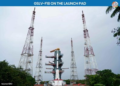
Mumbai, 01 November, 2026: The Indian Space Research Organisation (ISRO) successfully accomplished the GSLV-F18/NVS-03 mission on 30 October 2026 at 23:51 hours from the Satish Dhawan Space Centre (SDSC), Sriharikota.
The GSLV-F18 launch vehicle injected the Navigation Satellite NVS-03 into a precise Geosynchronous Transfer Orbit (GTO). Subsequently, first orbit manoeuvre completed on 31 October 2026 at 16:48 hours. Further manoeuvres are planned to place it in its designated geosynchronous orbital slot at 111.75° East.
The satellite is the third in India's series of five next-generation Navigation satellites and is designed to strengthen the Navigation with Indian Constellation (NavIC), enhancing India's capabilities in satellite-based navigation.
Did You Know? A spacecraft destined for geosynchronous or geostationary orbit is generally first placed in an elliptical Geosynchronous Transfer Orbit (GTO). This orbit has a low perigee (closest point to Earth) and a high apogee (farthest point from Earth). For a conventional GTO, the apogee is approximately 35,786 km above Earth's surface. Near apogee, the spacecraft fires its onboard propulsion system to raise its perigee and circularise its orbit. Additional manoeuvres may adjust its orbital inclination and position, depending on the target orbit. The propulsion system used for these orbit-raising manoeuvres is commonly called an Apogee Motor. In the case of NVS-03, the orbit-raising manoeuvre was performed using its Liquid Apogee Motor (LAM), a type of chemical rocket engine. |
Key Highlights of the Mission
Satellite Navigation System A Satellite Navigation System is a network of satellites that provides positioning, navigation and timing information. These satellites continuously transmit signals containing their location and precise timing information. Receivers, such as smartphones, vehicles and navigation devices, use signals from multiple satellites to determine their precise location, speed and direction. These systems support several applications, including route naviiesation, aircraft and ship tracking, precision agriculture, disaster management and telecommunications. Examples include the Global Positioning System (GPS) of the United States, and Navigation with Indian Constellation (NavIC) of India. |
Navigation Signals and Their Frequency Bands Navigation signals are radio-frequency signals transmitted by navigation satellites to receivers on Earth. These signals carry precise timing information and satellite-position data. Receivers use this information to calculate their location, speed and time. Frequency bands are specific ranges of radio frequencies used to transmit these signals. Satellite navigation systems use designated portions of the radio-frequency spectrum. Different bands allow signals to be transmitted and received at different frequencies. |
Geosynchronous Satellite Launch Vehicle (GSLV) The Geosynchronous Satellite Launch Vehicle (GSLV) is a three-stage launch vehicle developed by the Indian Space Research Organisation (ISRO) to place satellites into Geosynchronous Transfer Orbit (GTO) and Low Earth Orbit (LEO). The feature that makes GSLV unique from other launch vehicles is its final stage, which uses an indigenous Cryogenic Upper Stage. Additionally, the boosters used in GSLV are liquid-powered, popularly known as L-40, and use a hypergolic combination of Nitrogen Tetroxide (N₂O₄) and UH25 (a mixture of 75% Unsymmetrical Dimethylhydrazine (UDMH) and 25% Hydrazine Hydrate) Read More on GTO. The GSLV-F18 stands approximately 50 metres tall, with a lift-off mass of around 420 tonnes. It features a 3.4-metre-diameter metallic payload fairing and successfully carried the approximately 2,250 kg NVS-03 navigation satellite. Cryogenic Upper Stage: A cryogenic upper stage is the final stage of a launch vehicle that uses these propellants to provide the high efficiency needed to place satellites into their intended orbits. ISRO’s indigenous cryogenic upper stage used on GSLV employs liquid hydrogen (LH₂) as fuel and liquid oxygen (LOX) as oxidiser, both stored at extremely low temperatures. It replaced the Russian-supplied stage used in earlier GSLV flights, strengthening India’s self-reliance in advanced launch vehicle technology. |
Understanding NavIC: India's Indigenous Navigation System
Two Types of Navigation Services
NavIC provides two types of navigation services to cater to civilian and authorised strategic users.
Progress of the Next-Generation Navigation Satellite Series
The five-satellite NVS series is being developed to augment the NavIC constellation and ensure continuity of indigenous navigation services. To date, NVS-01, NVS-02, and NVS-03 have been launched, while NVS-04 and NVS-05 are in the pipeline. ISRO is working to boost the coverage, reliability and availability of NavIC services. Read more on India's Space Odyssey
NVS-01 – First Satellite of the Next/Second-Generation Series
NVS-02 – Second Satellite of the Series
NVS-04 and NVS-05 – Upcoming Satellites
One More Step Towards India's Space Sovereignty
The successful development and deployment of next-generation NavIC satellites mark another milestone in India's journey towards Atmanirbhar Bharat in advanced space technology. By strengthening indigenous satellite navigation capabilities, India is enhancing its ability to provide reliable positioning, navigation and timing services independently. These advancements reduce dependence on foreign satellite navigation systems for critical applications. They also strengthen India's technological capacity to design, develop and operate strategic space infrastructure. These efforts reinforce India's space sovereignty, technological self-reliance and growing role in the global space sector.
